
Information Technology
 The Information Technology Department is responsible for supporting the City of O'Fallon technology and communication systems. We enable other City departments to provide direct services to the residents of O'Fallon by installing, maintaining, and monitoring a wide array of devices, servers, and networks. The Information Technology Department is responsible for providing public Internet access to various City facilities and parks.
While most of our services are intended for City employees, elected officials, and cooperating intergovernmental agencies or businesses, our Geographic Information Systems provides both internal services as well as publicly available maps and information.
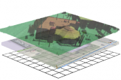
Geographic Information Systems (GIS) and MappingThe purpose of the GIS Group is to provide accurate location-based information and analysis to departments throughout the City and to the Public at large. In addition to traditional paper maps and static reports, the GIS team also creates a variety of online maps and live charts and reports.
Along with traditional data assembly via geodatabases and shapefiles, members of the public and vendors can consume map services directly from the City’s GIS site. The advantage of consuming these mapping REST services is that the data presented via these online map services is updated automatically with the most recent information available.
In addition, the GIS department leverages LiDAR elevation and ground condition information to enhance existing data. Common uses for LiDAR include obtaining elevation information for detailed analysis, creating contour lines and shaded relief of surface elevation, assisting with accurate building and above-ground asset placement, and performing line-of-sight analysis for specialized tasks.
GIS ongoing support includes managing assets and location information for Public Works buried pipe and asset management; working with Engineering concerns with new and existing development changes; coordinating with Community Development with regards to Permitting; Licensing, and Land management; and assisting Public Safety Dispatch with a variety of address and situational awareness map projects.
For further information, please contact a member of our team.